Turn sharp R.(E.) through Dingees Ravine to road. This point may also be reached from South Kent (Woodrow Station on the Berkshire Division of the N.Y.N.H.and H.R.R.) by road 2 1/4 mile W. to Bulls Bridge (Danbury-Canaan bus line on the U.S. Rt.7 ) and Dog Tails Corners 1 1/4 mile; turn R. 3/4 mile.
The trail up Schaghicoke Mountain turns R. before brook crossing. After crossing the gulf and climbing the shoulder, the trail crosses the plateau to the State Line on the summit.
The Blue Blazes of the Connecticut section begin here. South Rock and Indian Rocks give extensive views of the Housatonic Valley. On the descent the main trail crosses through Dry Gulch and
Rattlesnake Den. For those who are afraid of snakes there is a detour [A] to the W. on more even ground. (on reaching the River Road at the base of the mountain one may go L. to Kent, or R. to Bulls Bridge, passing the old reservation and burial ground of the Schaghicoke Indians.
Here lies Princess Mauwee, and the weather beaten shacks nearby are still inhabited by a mixed race)
Trail continues N. across Thayer Brook. (at Mt.Algo, the L. fork goes through the notch to the summit.) [B] The R. fork crosses Pine Ledge, with moss and fern covered boulders and on the steep descent affords glimpses of the valley and Kent School.
On reaching the highway turn L. to Route 341 (8m. by trail from Webatuck) To R. Kent is 3/4 mile. From either Wingdale or South Kent the distance would be about 11 miles.
The trail passes a large glacial boulder and over Macedonia Mountain, then along a wood-road, formerly the route of the POUGHKEEPSIE-HARTFORD STAGE LINE.
Descending to the Macedonia valley, the trail follows the road along the beautiful brook which flows through Nodine Hollow.
Passing over the St.John Ledges, there is a sensational steep rock descent to the river road along the Housatonic. This road may be followed L. 1 mile to Flanders Bridge (R.R.and Bus); or R.(S.)to Kent, making a round trip of about 16 miles.
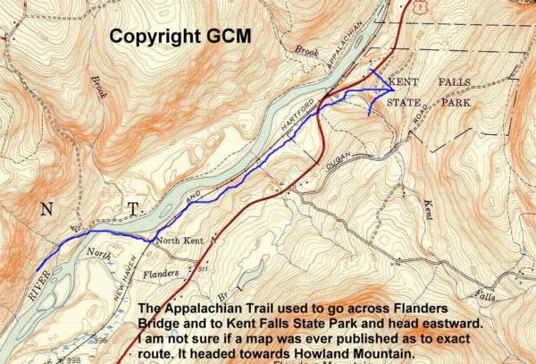
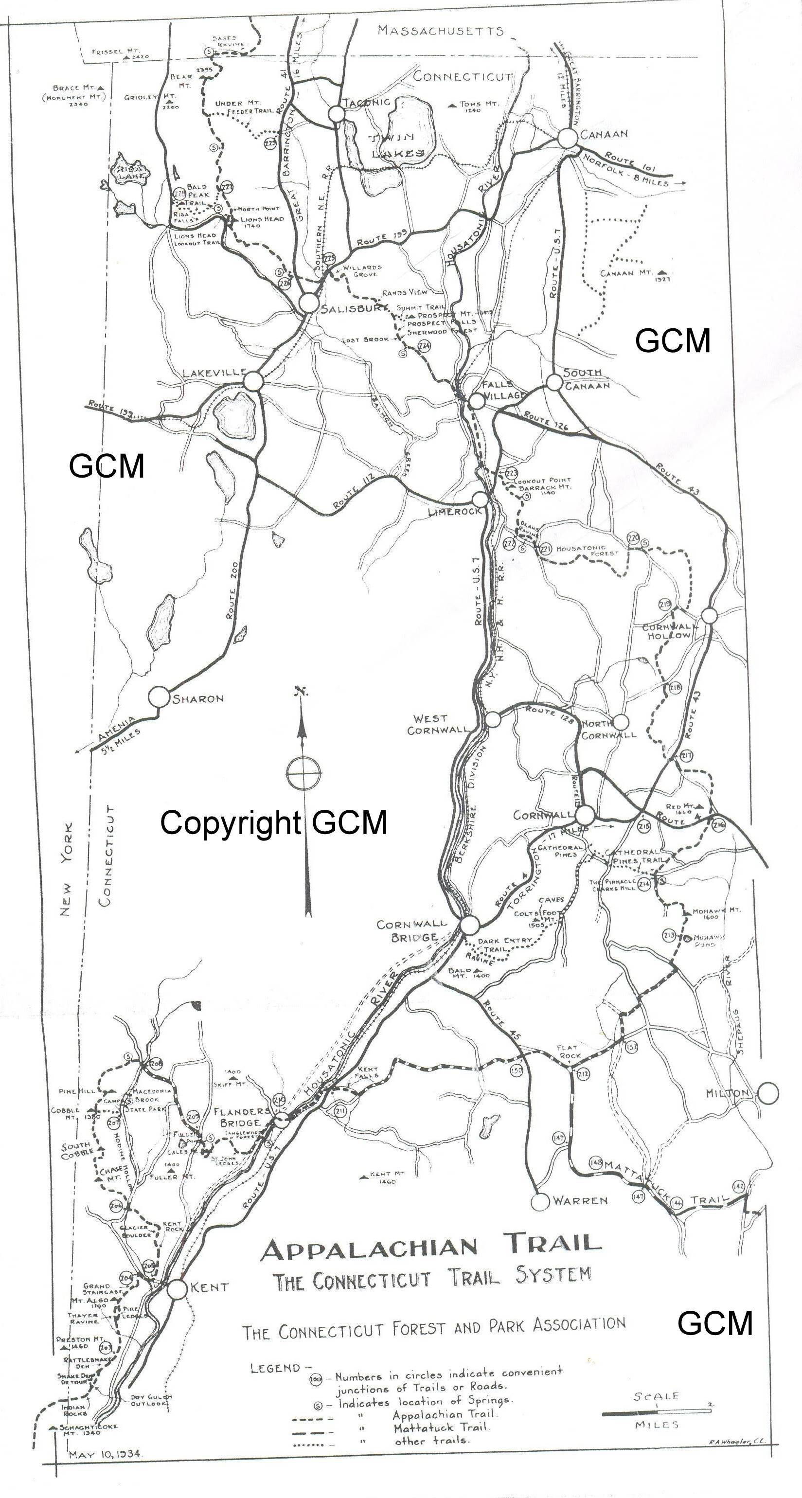
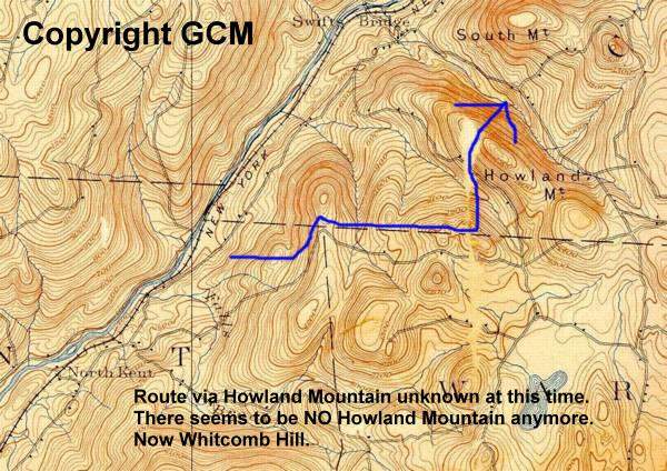
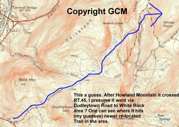
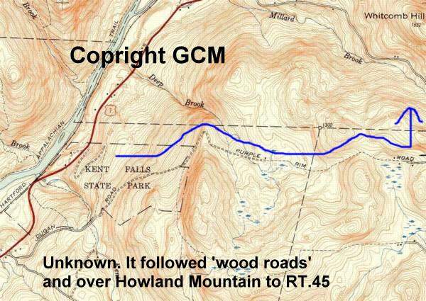
Old country roads are then followed to the E. over the slope of Howland Mountain and the Warren plateau.The vistas are rewarding.
At about 8 miles from Flanders Bridge the trail crosses Route 45, and a mile farther, at Flat Rock, reaches the junction of the Mattatuck Trail.
One of the sign boards points towards Mt. Katahdin, a second to Mt. Oglethorpe, and a third to New Haven, a 62 miles away by the Mattatuck and the Quinnipiac trails of the Connecticut system.
The Appalachian Trail continues 3.8 miles to Mohawk Pond, another state park, and climbs through the Mohawk State Forest to the observation tower on Mohawk Mountain (1,680 feet) , with extensive views.
There are facilities for camping at various points in the Forest.The mountain, according to tradition, recieved its name from the beacon lighted by the local indians to warn their tribesmen of the approach of the Mohawks, who raided the territory and collected tribute. Continuing down the mountain, Clarks Hill offers a fine panorama to the N. and a side [D] trail leads down through the beautiful Calhoun Pines to Cornwall Village.
The Appalachian Trail continues N.,with a side trail [E] to the Spruce Bog,a feature rare in Connecticut. Route 4 is reached at Bunker Hill,named for one of the last families of the Schaghicook Indians.
(By following Rt. 4 to the L. through Cornwall one reaches Cornwall Bridge, on Rt.7, 19 miles by trail from Flanders Bridge.)
The trail then enters the Housatonic State Forest, passing a short distance from the musical colony on Music Mountain, and descends through the wild Deans Ravine.
After following the River Road (U.S.Rt. 7) below Lime Rock Station for a short distance, the trail climbs to the summit of Barrack Mountain , descends its N.W. slope and follows the Housatonic River through a pine grove to the crossing at Falls Village.
As a side trip, CANAAN MOUNTAIN, 5 miles north on Route 7, offers an unusually fine panorama from its western cliffs. The existing trail, at the N. W. corner, may be reached by the gravel road S.of the Blackberry River, just S. of Canaan; after a mile strike up the hill W. of a grove of pines.
[website editor looking for information on old Canaan Mountain Trails-I saw reference to such years ago but reference source ?]
It descends into the Salisbury Valley over Barkmeteth Ridge, through one of the finest hemlock forests on the trail, to Rt. 199, 1/2 mile N. of Salisbury.
The trail crosses the Salisbury Valley on the Cobble Road, crossing the Undermountain Road (Rt.41) and continuing to Bell's Woods, where it ascends steeply over a limestone outcrop and along pastures and woods to Lions Head Road. The trail then ascends the slope of Lions Head. The views on the ascent and from the summit (N. and S. viewpoints) are among the finest in Connecticut. The trail here turns N. along the ridge and follows the old Mt.Riga coal road, a relic of charcoal days.
A few miles to the W. is Forge Pond, once the seat of an important iron industry, where the anchors of the frigate Constitution were forged. A marked side trail [E] leads to a fine outlook on Mt.Riga.
At the foot of Bear Mountain, the highest point in Connecticut, a rugged trail climbs to the summit, and elevation of 2,355 ft. An abrupt descent leads to Sage's Ravine, where the stream with its interesting rocks and falls is followed E. for a short distance.
The Massachusetts line is reached where the logging road from Race Mountain crosses the stream. A side trail [F] leads E. from Bear Mountain to the Undermountain Road, which may be followed 2 3/4 miles S. to Salisbury. Various circuits to the W. may be made by old roads.
Stops should be at Kent, Kent Falls, Cornwall, and Falls Village. The southern terminus is readily accessible from Wingdale on the Harlem Division; Kent is on the N.Y.N.H.& H. The northern exit must be the side trail from Bear Mountain to the Undermountain Road and thence 2 and 3/4 mile S. to Salisbury along the hardsurface Undermountain Road.
Salisbury, Falls Village and Cornwall Bridge are on the bus lines of the New England Transportation Company. The former is on the bus line from Canaan (N.Y.N.H.&H) to Millerton (Harlem Division) and the latter two on the Canaan-Danbury (N.Y.N.H.&H) bus route.
There is no railroad or bus service at Cornwall, which is 3 1/2 miles from Cornwall Bridge on Rt.7. To assure connections, time tables for these bus routes should be obtained from the New England Transportation Company at Danbury,Connecticut.
This itinerary is suggested:
------?
First Day: Wingdale to Kent,10 3/4 miles; Accomodations at Kent Inn and Howland House;
Second Day; Kent to Kent Falls, 14 miles; Accomodations at Thompson's Housatonic Farm (1/2 mile N. on highway from Kent Falls Park);
Third Day; Kent Falls to Cornwall via Calhouns Pines side trail 13 1/2 mile; Accomodations with Mrs.Frank Whitcomb, Cornwall, Conn.
Fourth Day: Cornwall to Falls Village,15 miles; Accomodations with Miss Sophia Aldrich, Falls Village.
Fifth Day: Falls Village to Salisbury via Bear Mountain and Undermountain Road, approximately 16 miles; Accomodations at White Hart Inn,Salisbury.
